About
Driven to Document the World from Above
We are passionate about using technology to help our clients achieve their goals. Whether you need to map out a construction site, create a marketing video, or monitor environmental changes, we have the expertise and equipment to get the job done quickly, safely, and affordably. Contact us today to learn more about how we can help you harness the power of drone technology.
OUR SERVICES
Aerial Photo
Our aerial photo services offer breathtaking, panoramic images of locations, properties and events.
Aerial Video
Aerial video services provide stunning, bird’s-eye views of landscapes, properties, events and more.
2D Orthamosaic
Capture extensive data of large areas quickly and efficiently, ideal for urban planning or environmental studies.
3D Mapping
Obtain detailed 3D models of your site to aid in construction, infrastructure development, and land management.
Why Choose Us
Years of Experience
Choose us for our unmatched precision in drone mapping, utilizing the latest technology to deliver accurate and detailed visual data that helps drive informed decisions.
Professional Pilots
We blend cutting-edge technology with a customer-first approach, providing bespoke mapping solutions that meet your specific needs and help you make data-driven decisions.
Affordable Price
Rely on our efficient and innovative approach, harnessing high-definition imagery and sophisticated data processing for rapid delivery of precise maps and 3D models.
Get better insights today!
Experience our comprehensive 3D property scans, intricately designed to provide you with a thorough and insightful understanding of your property. Don’t miss out on the most detailed visual data technology can offer. Reach out to us today and let our team transform the way you perceive property analysis.
FAQ
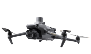
Our fleet includes advanced drones such as the Mavic 3 Enterprise with an RTK receiver for accurate mapping, the DJI AIR2S for high-resolution video and photography, and the DJI FPV Drone for capturing dynamic and fast-action shots.
Our drones can cover up to 120 acres in a daily flight session of up to 2 hours, providing efficient and comprehensive aerial mapping services.
In a single 30-minute session, we can cover up to 30 acres with an impressive Ground Sampling Distance (GSD) of 1 cm per pixel, ensuring detailed and accurate imaging.
We cater to a diverse range of industries, including real estate, construction, agriculture, and environmental monitoring. Our expertise allows us to tailor solutions to meet the specific needs of each client within these sectors.
We prioritize safety and compliance by maintaining Business liability coverage up to 10 million. Additionally, we adhere to CAA Part 101 rules, ensuring responsible and lawful drone operations. You can find more details about CAA Part 101 rules here.
